Trustworthy Digital Twin Technologies for Resilient Infrastructure
Research Overview
While Digital Twins have become an important tool for urban planning and smart-city development, rural regions remain an emerging frontier for this technology. A Digital Twin is a dynamic virtual representation of a physical asset, process, or environment that is continuously updated with real-world data to reflect the state and behavior of its physical counterpart. By creating this “virtual mirror,” digital twins can support scenario simulation, performance monitoring, predictive maintenance, and data-driven decision-making. However, rural deployments face unique challenges, including sparse sensing infrastructure, limited historical data, constrained computing resources, and extreme environmental conditions that can make existing AI models fragile in low-density and high-altitude settings.
Through interdisciplinary collaborations with researchers across multiple areas of expertise, we are developing high-fidelity digital twins for rural places, with current pilot studies focused on Laramie and Afton, Wyoming. This research treats trust as a measurable systems property by integrating Artificial Intelligence (AI), 3D development tools, computer vision, and real-time sensing to create trustworthy and practical digital twin solutions. By bridging the gap between advanced digital twin technologies and rural deployment needs, this work aims to provide communities with data-driven foresight for monitoring infrastructure, anticipating risks, and supporting resilient services under the complex environmental conditions of the Mountain West.
Ongoing Research
Resilient Computer Vision for Blowing Snow
Reliable visual perception is a functional requirement for safe autonomous and human-driven transportation, yet in high-altitude regions like Wyoming, this capability is frequently compromised by blowing snow. While standard falling snow is a well-studied degradation in computer vision, blowing snow represents a novel and significantly more complex challenge. It involves high-velocity winds that suspend fine ice particles, creating dense volumetric scattering during the day and pronounced light bloom around artificial sources at night. In environments like Wyoming's I-80 corridor, these "whiteout" conditions create a severe safety risk that traditional de-noising models are unequipped to handle.
The core scientific hurdle is the non-stationary nature of the degradation. Unlike static rain or light snow, blowing snow dynamically obscures scene geometry in a way that traditional filters cannot easily resolve. Our research focuses on a framework designed to isolate the intrinsic scene information from these intense environmental perturbations. By treating the weather as a distinct, separable signal, the system can "see through" high-mass blizzard concentrations to recover underlying infrastructure. This ensures that Digital Twins maintain high-fidelity synchronization even during the extreme, unpredictable atmospheric events characteristic of the Mountain West.
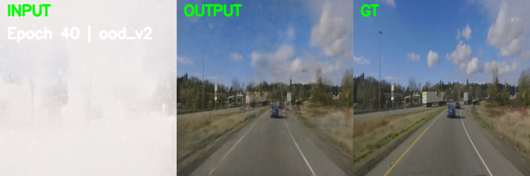
Visualizing the transition from basic de-noising to robust structural restoration on extreme "whiteout" blizzard samples.
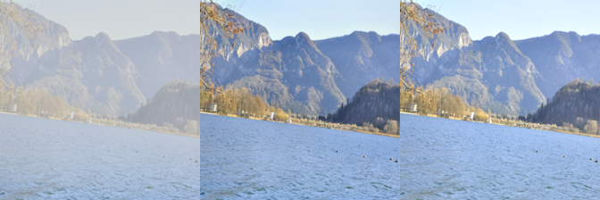
Universal Adverse-Weather Restoration
In traditional computer vision, "all-weather restoration" is a significant hurdle because different weather conditions, such as rain, fog, snow, or low-light, affect image pixels through vastly different physical processes. Rain adds directional streaks, fog causes uniform contrast loss, and low-light introduces non-stationary sensor noise. Most existing solutions require separate, heavy models for each condition, which creates a "computational bottleneck" for resource-constrained rural infrastructure.
For a Digital Twin to be effective, it requires a continuous, clean data stream from the physical world. If the sensors in Laramie or Afton are "blinded" by a sudden transition from fog to a night-time blizzard, the Digital Twin loses its synchronization with reality. To maintain a Trustworthy AI framework, we develop lean, unified models that can identify specific weather degradations and adapt restoration strategies in real-time without overwhelming the hardware.
Our approach addresses the efficiency gap in multi-weather restoration by utilizing multimodal embedding and hybrid attention backbones to handle diverse degradations within a single architecture. By optimizing the parameter space, we achieve a 56.5% reduction in model size compared to current benchmarks, making these solutions ideal for deployment on the low-power edge sensors used in our Laramie and Afton pilots.
CDD-11 Dataset: Input / Output / Ground Truth

LOL Dataset: Input / Output / Ground Truth

SNOW100K Dataset: Input / Output / Ground Truth
Predictive Digital Twins for Rural Mobility
Parking and transportation management in rural and medium-scale retail hubs face a critical bottleneck: a lack of proactive foresight. While real-time sensing provides status updates, most systems remain reactive, offering no path for predictive facility management. From a Digital Twin perspective, the primary challenge is decision-fragility in environments where historical data is scarce. Current frameworks often assume access to massive datasets or high-bandwidth cloud pipelines, conditions rarely met in localized rural infrastructures.
Without a synchronized virtual mirror that can simulate "what-if" scenarios, facility managers are unable to validate operational policies or forecast turnover in real-time. The research problem involves bridging this gap, transforming descriptive monitoring into a predictive intelligence layer. This requires creating a framework that can synthesize realistic behavior patterns and deliver multi-horizon forecasts within resource-constrained environments, ensuring the virtual environment remains a faithful and useful mirror of the physical asset's future state.
Methodology & Technical Strategy
Our approach bridges the gap between complex model perception and real-world algorithmic control through a structured development lifecycle tailored for the unique challenges of rural Wyoming:
- Drone Photogrammetry: Deploying autonomous UAVs to perform high-precision scans for environment regeneration and 3D reconstruction.
- Computer Vision Arrays: Strategically placed static sensors monitoring real-time traffic, parking turnover, and infrastructure health.
- Trustworthy AI: Integrating robust de-noising and validation layers to ensure reliable system decisions under "out-of-distribution" environmental shifts.
- Geospatial Integration: Utilizing Cesium 3D Tiles and CesiumJS to stream massive, structurally accurate datasets into a synchronized virtual environment.
- Physics-Informed ML: Constraining our deep learning models with physical principles to ensure all predictions are realistic and admissible.